1
Lecture 1: Geomorphology
• Questions
– What is geomorphology? What are the relationships
between elevation, slope, relief, uplift, erosion, and
isostasy?
– How do you measure the rates of geomorphic
processes?
– What does geomorphology have to do with tectonics?
Basic principle:
Every feature of the landscape is
there for a reason. We just have
to be smart enough to figure out
what the reason is.

2
What is Geomorphology?
• Geomorphology is the study of landforms, i.e. the
shape of the Earth’s surface. It attempts to explain
why landscapes look as they do in terms of the
structures, materials, processes, and history
affecting regions.
• Geomorphology relates to all the other disciplines
of geology in two directions:
– Tectonics, petrology, geochemistry, stratigraphy, and
climate determine the geomorphology of the earth and
its regions by controlling the principal influences on
landscape.
– Therefore evidence from observations of the landscape
in turn constrain the tectonic, petrologic, geochemical,
stratigraphic, and climatic history of the earth and its
regions.

3
Uses of geomorphology
• Consider how frequently we infer the geologic history
of a region from observation of the landforms.
• We will see many examples :
– Tectonic motions create geomorphic features like fault scarps and grabens;
from observation of scarps and grabens we infer the sense of tectonic
motions and something about their ages.
– Volcanic activity creates calderas; from the form of the caldera we learn
about the mechanism of eruption.
– Granite weathers to rounded jointstones; from observation of the shape of
boulders and outcrops we can quickly map granite plutons; from the shape
of these rocks we infer how they joint and how they chemically weather.
– Resistant and weak strata determine the shapes of cliffs; from distant
observations of cliff shapes and local knowledge of stratigraphy, we can
map outcrops as far as the eye can see.
– Glacial processes create geomorphic expressions such as moraines; from
the position, form, and age of the moraines we learn about paleoclimate
and the nature of glaciers.

4
Relevance of geomorphology
• Geomorphology is important because people live on
landforms and their lives are affected (sometimes
catastrophically) by geomorphic processes:
• Slope determines whether soil accumulates and makes arable land
• Slope stability controls landslides
• Mountains drastically affect the weather: rainshadows, monsoons
• This is also a two-way process: Human action is one of
the major processes of geomorphic evolution:
• People have been building terraced hillsides for thousands of years
• People dam rivers, drain groundwater, engineer coastlines
• People plant or burn vegetation on a huge scale
• People are paving the world
• People are changing the climate
5
Geomorphic Concepts
• Important: a mountain is a feature of relief, not elevation (a high area of
low relief is a plateau)
– Slope controls the local stability of hillsides and sediment
transport
– Relief controls the regional erosion rate and sediment yield
– Elevation directly affects erosion and weathering only through
temperature, however, high elevation and high relief are
generally pretty well-correlated (with glaring exceptions, like
Tibet and the Altiplano)
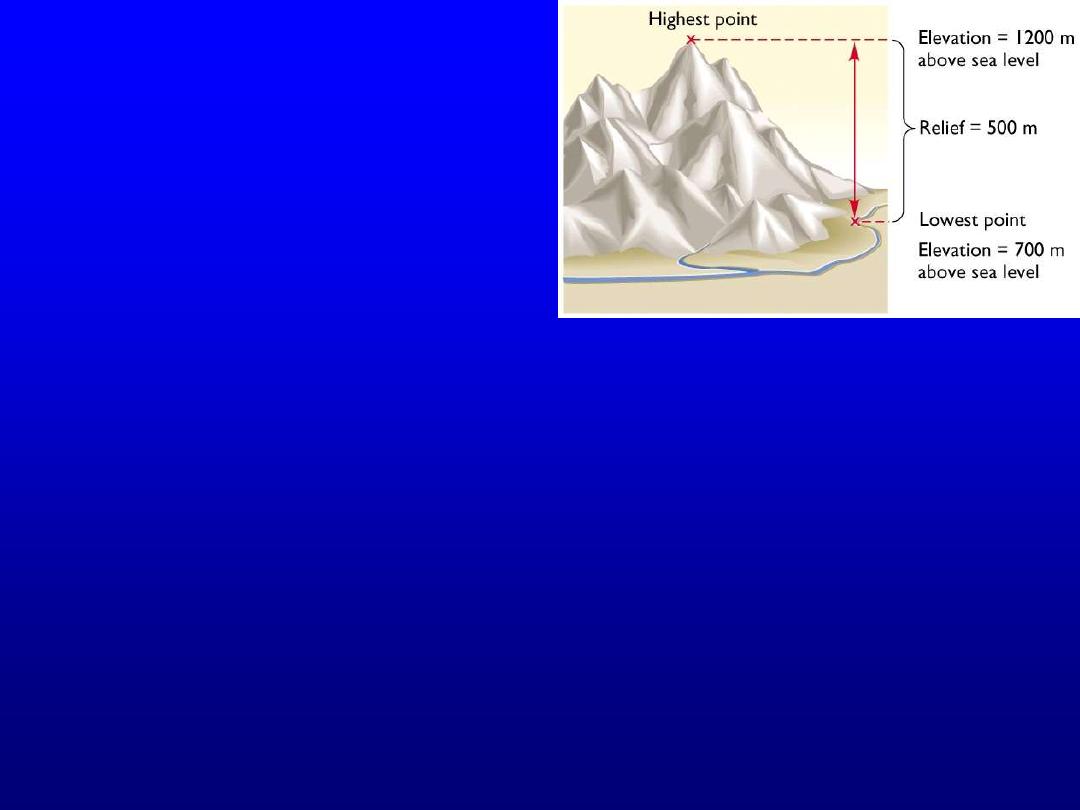
• Elevation: height above sea level
• Slope: spatial gradients in
elevation
• Relief: the contrast between
minimum and maximum
elevation in a region
How high is this mountain?

6
Geomorphic Concepts
• Uplift/subsidence
– vertical motions of the crust (i.e., of material points)
• Accumulation/denudation
– vertical change in the position of the land surface with respect
to material points in the bedrock.

7
“Process” geomorphology
• Quantitative, physically based analysis of morphology
in terms of endogenic and exogenic energy sources
• Basics of process geomorphology
– 1) Assume balance between forms and process (equilibrium
and quasi-equilibrium)
– 2) Balance created and maintained by the interaction between
energy states (kinetic and potential); force and resistance.
– 3) Changes in force-resistance balance may push the
landscape and processes too far: thresholds of change
exist: fundamental change of process and thus form.
– 4) Processes are linked with multiple levels of feedback.
– 5) Geomorphic analysis occurs at multiple spatial and
temporal scales.
8
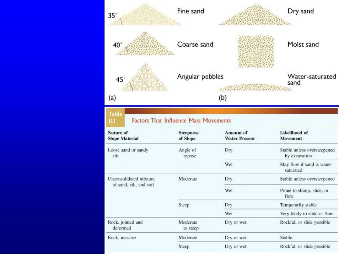
Process
geomorphology
• An example of a
quantifiable
process: hillslope
evolution
• What controls
stability of a
slope? Lithology
and water, mostly
9
Hillslope evolution:
qualitative approach
Some rocks are
resistant to erosion
(they form cliffs),
some are weak (they
form slopes).
Resistant and weak
are qualitative terms,
but useful for
describing landscape
evolution.
10
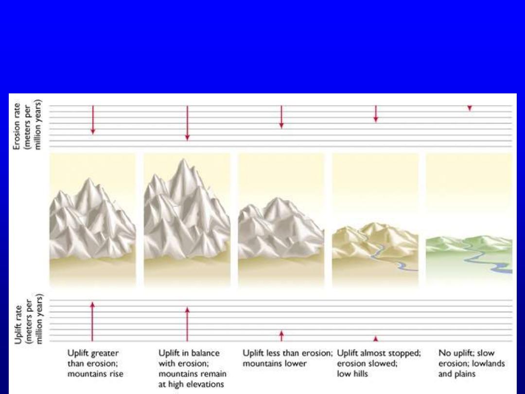
Feedbacks in geomorphology
• The idea that, in the absence of tectonic disturbance, the negative
feedback between elevation and erosion tends to eliminate relief is
the basis of W. M. Davis’ theory of landscape evolution:

11
Geomorphology and Tectonics
• For young tectonic activity, elevation and relief are
direct expressions of tectonic activity.
• For old stable terrains, elevation and relief become
expressions of relative rates of erosion.
– Thus, in California, anticlines are hills or mountains, but in
Pennsylvania, anticlines may just as well be valleys if the
older strata exposed in anticlinal cores are easily eroded.
• Ancient tectonic features must be recognized by the
relations of the rocks around them. Current tectonic
activity can be monitored by seismology and geodesy.
Everything in between depends on geomorphology.
– Geomorphic expression is by far the easiest way to locate
faults at the surface, and far more precise (at the surface) than
seismology.

12
Geomorphology and Tectonics
• When the form of an original geomorphic feature is known, then
the magnitude of tectonic deformation can be determined by
measuring its current shape. Examples:
– fault scarps start from nothing, so height of scarp gives magnitude of total
dip-slip displacement.
– undisturbed drainages presumably go straight across faults; lateral offset
gives total strike-slip displacement.
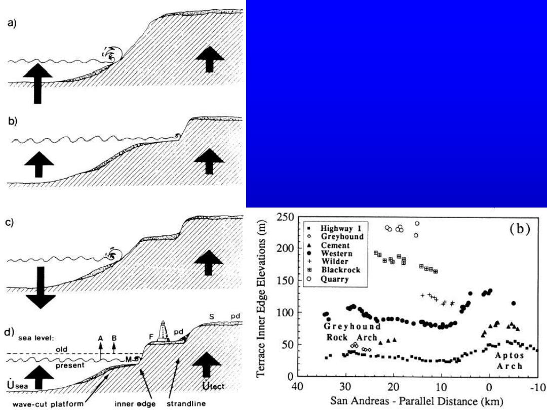
– marine terraces start at sea-level, so height of wave-cut platform gives
total uplift since abandonment of terrace.
– river terraces start with longitudinal profile of riverbed; disturbances in
shape and slope give total deformation and tilt.
• When, furthermore, the age of the geomorphic feature is also
known, then the rate of tectonic deformation is determined as
well.
– How do you date geomorphology? This is a different problem from dating
rocks!
13
Geomorphology and Tectonics
• Topographic profiles of uplifted
marine terraces at Santa Cruz, CA,
give two kinds of information:
• Total vertical uplift from height of wave-
cut platforms initially at sea level
• Relative deformation along shore from
shape of initial horizontal markers
• What additional type of data would be
useful here?