
Geomorphology
(from Greek: geo, "earth"; morph, "form"; and logos, "study") is the
scientific study of landforms and the processes that shape them.
Geomorphologists seek to understand why landscapes look the way they
do, to understand landform history and dynamics and to predict changes
through a combination of field observations, physical experiments
and numerical modeling.
Geomorphologyis
practiced
within physical
geography, geology, geodesy, engineeringgeology, archaeology and geote
chnical engineering.
This broad base of interest contributes to many research styles and
interests within the field.
Overview
The surface of Earth is modified by a combination of surface processes
that sculpt landscapes, and geologic processes that cause tectonic
uplift and subsidence.
Two processes:-
-Exogenic processes, (Tectonic, Volcanic)
-Endogenic processes (Surface processes) comprise the action
of water, wind, ice, fire, and living things on the surface of the Earth,
along with chemical reactions that form soils and alter material properties,
the stability and rate of change of topography under the force of gravity,
and other factors, such as (in the very recent past) human alteration of the
landscape (Fluvial, Glacial, Aeolian, Marine….).Many of these factors are
strongly mediated by climate.
Geologic processes include the uplift of mountain ranges, the growth
of volcanoes, isostatic changes in land surface elevation (sometimes in
response to surface processes), and the formation of deep sedimentary
basins where the surface of Earth drops and is filled with
material eroded from other parts of the landscape. The Earth surface and
its topography therefore are an intersection of climatic, hydrologic,
and biologic action with geologic processes.
The broad-scale topographies of Earth illustrate this intersection of surface
and subsurface action. Mountain belts are uplifted due to geologic
processes. Denudation of
these
high
uplifted
regions
produces sediment that is transported and deposited elsewhere within the

landscape or off the coast. On progressively smaller scales, similar ideas
apply, where individual landforms evolve in response to the balance of
additive processes (uplift and deposition) and subtractive processes
(subsidence and erosion). Often, these processes directly affect each other:
ice sheets, water, and sediment are all loads that change topography
through flexural isostasy. Topography can modify the local climate, for
example through orographic precipitation, which in turn modifies the
topography by changing the hydrologic regime in which it evolves. Many
geomorphologists are particularly interested in the potential for feedbacks
between climate and tectonics mediated by geomorphic processes.
Fluvial geomorphologists
focus
on rivers,
how
they transport
sediment, migrate across the landscape, cut into bedrock, respond to
environmental and tectonic changes, and interact with humans. Other
geomorphologists study how hillslopes form and change. Still others
investigate the relationships between ecology and geomorphology.
Because geomorphology is defined to comprise everything related to the
surface of Earth and its modification, it is a broad field with many facets.
Practical applications of geomorphology include hazard assessment (such
as landslide prediction
and mitigation),
river
control
and stream
restoration, and coastal protection. Planetary geomorphology studies
landforms on other terrestrial planets such as Mars. Indications of effects
of wind, fluvial, glacial, mass
meteor
impact, tectonics and volcanic processes are studied. This effort not only
helps better understand the geologic and atmospheric history of those
planets but also extends geomorphological study of Earth. Planetary
geomorphologists often use Earth analogues to aid in their study of
surfaces of other planets.
History
With some notable exceptions (see below), geomorphology is a relatively
young science, growing along with interest in other aspects of the earth
sciences in the mid-19th century. This section provides a very brief outline
of some of the major figures and events in its development.
Ancient geomorphology[edit]
The first theory of geomorphology was arguably devised by the
polymath Chinese scientist and statesman Shen Kuo (1031-1095 AD).
This was based on his observation of marine fossil shells in a geological
stratum of a mountain hundreds of miles from the Pacific Ocean.
Early modern geomorphology
The term geomorphology seems to have been first used by Laumann in an
1858 work written in German. Keith Tinkler has suggested that the word

came into general use in English, German and French after John Wesley
Powell and W. J. McGee used it during the International Geological
Conference of 1891.
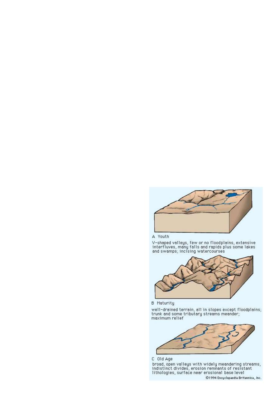
An early popular geomorphic model was the geographical cycle or cycle
of erosion model of broad-scale landscape evolution developed
by William Morris Davis between 1884 and 1899. It was an elaboration of
the uniformitarianism theory that had first been proposed by James
Hutton (1726–1797).
With
regard
to valley forms,
for
example,
uniformitarianism posited a sequence in which a river runs through a flat
terrain, gradually carving an increasingly deep valley, until the side
valleys eventually erode, flattening the terrain again, though at a lower
elevation. It was thought that tectonic uplift could then start the cycle over.
In the decades following Davis's development of this idea, many of those
studying geomorphology sought to fit their findings into this framework,
known today as "Davisian". Davis's ideas are of historical importance, but
have been largely superseded today, mainly due to their lack of predictive
power and qualitative nature.
In the 1920s, Walther Penck developed an alternative model to Davis's.
Penck thought that landform evolution was better described as an
alternation between ongoing processes of uplift and denudation, as
opposed to Davis's model of a single uplift followed by decay. Penck's
ideas were not recognised until many years after his death, perhaps
because his work was not translated into English, he was involved in
disputes with Davis, and he died young.
During the early 1900s, the study of regional-scale geomorphology was
termed "physiography". Physiography later was considered to be a
contraction of "physical" and "geography", and therefore synonymous
with physical geography, and the concept became embroiled in
controversy surrounding the appropriate concerns of that discipline. Some
geomorphologists held to a geological basis for physiography and
emphasized a concept of physiographic regions while a conflicting trend
among geographers was to equate physiography with "pure morphology,"
separated from its geological heritage. In the period following World War
II, the emergence of process, climatic, and quantitative studies led to a
preference by many Earth scientists for the term "geomorphology" in
order to suggest an analytical approach to landscapes rather than a
descriptive one.
Quantitative geomorphology
Following the early trail blazing work of Grove Karl Gilbert around the
turn
of
the
20th
century,
a
group
of
natural
scientists, geologists and hydraulic
including Ralph
Strahler began to research the form of landscape elements such
as rivers and hillslopes by
taking
systematic,
direct,
quantitative
measurements of aspects of them and investigating the scaling of these
measurements. These methods began to allow prediction of the past and
future behavior of landscapes from present observations, and were later to
develop into what the modern trend of a highly quantitative approach to
geomorphic problems.
Qualitative geomorphology
It's describe the morphology of the landforms in description way with no
need for systematic measurements or digital analysis.
Processes
Modern geomorphology focuses on the quantitative analysis of
interconnected processes. Modern advances in geochronology, in
particular cosmogenic
luminescence dating and low-temperature thermochronology have enabled
us for the first time to measure the rates at which geomorphic processes
occur on geological timescales. At the same time, the use of more precise
physical measurement techniques, including differential GPS, remotely
sensed digital terrain models and laser scanning techniques, have allowed
quantification
and
study
of
these
processes
as
they
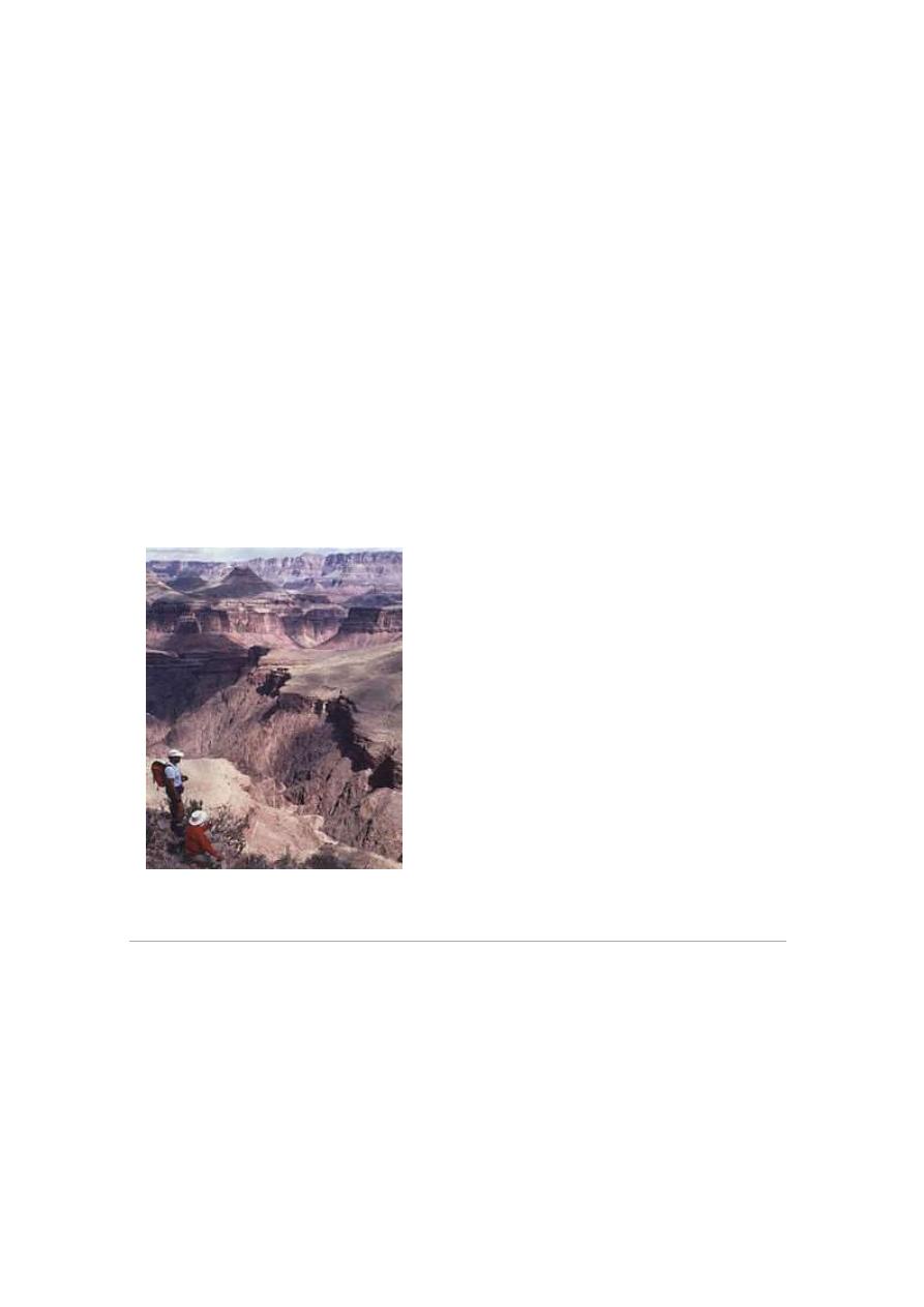
Grand Canyon, Arizona, USA
happen. Computer simulation and modeling may then be used to test our
understanding of how these processes work together and through time.
Geomorphologically relevant processes generally fall into:-
(1) the production of regolith by weathering and erosion.
(2) the transport of that material.
(3) its eventual deposition.
Although there is a general movement of material from uplands to
lowlands, erosion, transport, and deposition often occur in closely spaced
tandem all across the landscape.
The nature of the processes investigated by geomorphologists is strongly
dependent on the landscape or landform under investigation and the time
and length scales of interest. However, the following non-exhaustive list
provides a flavor of the landscape elements associated with some of these.
Primary surface processes responsible for most topographic features
include wind, waves, chemical
wasting, groundwater movement,
action, tectonism, and volcanism.
Fluvial processes
Main article: Fluvial
Rivers and streams are not only
conduits of water, but also of sediment.
The water, as it flows over the channel
bed, is able to mobilize sediment and
transport it downstream, either as bed
load, suspended load or dissolved load.
The rate of sediment transport depends
on the availability of sediment itself
and on the river's discharge.
Rivers are also capable of eroding into
rock and creating new sediment, both
from their own beds and also by
coupling to the surrounding hillslopes.
In this way, rivers are thought of as
setting the base level for large scale
landscape evolution in non-glacial
environments. Rivers are key links in
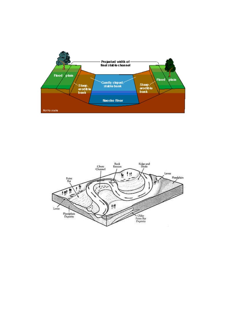
the connectivity of different landscape elements.
As rivers flow across the landscape, they generally increase in size,
merging with other rivers. The network of rivers thus formed is a drainage
system and is often dendritic (tree-like), but may adopt other patterns
depending on the regional topography and underlying geology.
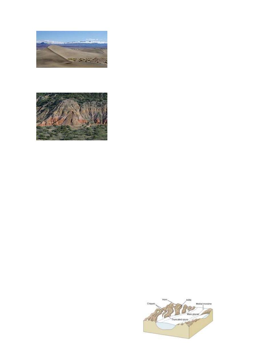
Aeolian processes
Aeolian processes pertain to the activity of the winds and more
specifically, to the winds' ability to shape the surface of the Earth. Winds
may erode, transport, and deposit materials, and are effective agents in
regions
with
sparse vegetation and
a
large
supply
of
fine,
unconsolidated sediments. Although water and mass flow tend to mobilize
more material than wind in most environments, aeolian processes are
important in arid environments such as deserts.
Hillslope processes
and rock move
downslope
under
the
force
flows,
topples,
and
falls.
Such mass
wasting occurs on both terrestrial and submarine slopes, and has been
observed on Earth, Mars, Venus, Titan and Iapetus.
Ongoing hillslope processes can change the topology of the hillslope
surface, which in turn can change the rates of those processes. Hillslopes
that steepen up to certain critical thresholds are capable of shedding
extremely large volumes of material very quickly, making hillslope
processes an extremely important element of landscapes in tectonically
active areas.
On Earth, biological processes such as burrowing or tree throw may play
important roles in setting the rates of some hillslope processes.
Glacial processes
Glaciers, while geographically restricted, are effective agents of landscape
change. The gradual movement of ice down a valley causes abrasion and
plucking of the underlying rock. Abrasion produces fine sediment,
termed glacial flour. The debris transported by the glacier, when the
glacier recedes, is termed a moraine. Glacial erosion is responsible for U-
shaped valleys, as opposed to the V-shaped valleys of fluvial origin.
Features of a glacial landscape
The way glacial processes interact with other landscape elements,
particularly hillslope and fluvial processes, is an important aspect of Plio-
Pleistocene landscape evolution and its sedimentary record in many high
mountain environments. Environments that have been relatively recently
glaciated but are no longer may still show elevated landscape change rates
compared to those that have never been glaciated. Non-glacial geomorphic
processes which nevertheless have been conditioned by past glaciation are
termed para-glacial processes.
This
concept
contrasts
with peri-
glacial processes, which are directly driven by formation or melting of ice
or frost.
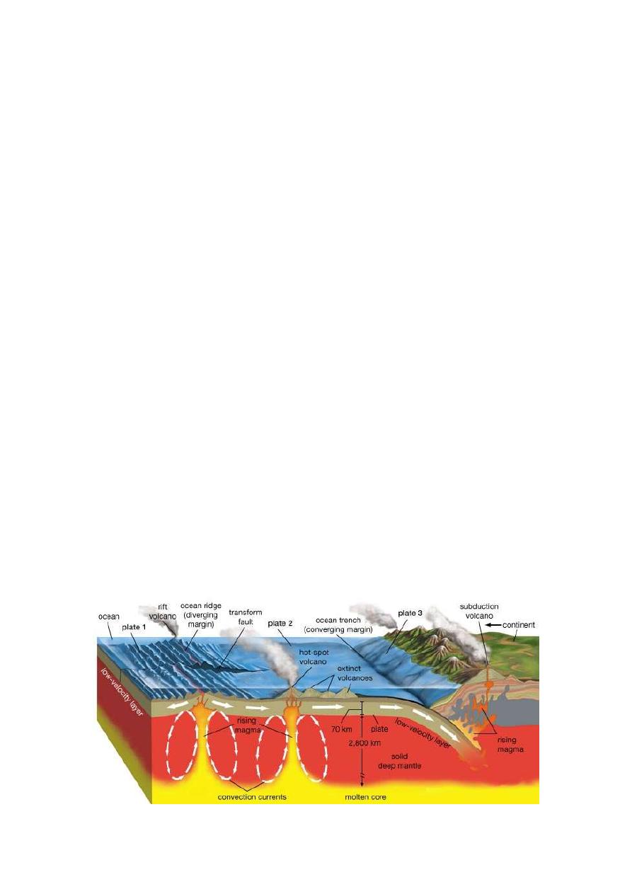
Tectonic processes
Tectonic effects on geomorphology can range from scales of millions of
years to minutes or less. The effects of tectonics on landscape are heavily
dependent on the nature of the underlying bedrock fabric that more less
controls
what
kind
of
local
morphology
tectonics
can
shape. Earthquakes can, in terms of minutes, submerge large areas of land
creating new wetlands. Isostatic rebound can account for significant
changes over thousand or hundreds of years, and allows erosion of a
mountain belt to promote further erosion as mass is removed from the
chain and the belt uplifts. Long-term plate tectonic dynamics give rise
to orogenic belts, large mountain chains with typical lifetimes of many
tens of millions of years, which form focal points for high rates of fluvial
and hillslope processes and thus long-term sediment production.
Features of deeper mantle dynamics such as plumes and delamination of
the lower lithosphere have also been hypothesised to play important roles
in the long term (> million year), large scale (thousands of km) evolution
of the Earth's topography (see dynamic topography). Both can promote
surface uplift through isostasy as hotter, less dense, mantle rocks displace
cooler, denser, mantle rocks at depth in the Earth.

Igneous processes (Volcanic)
Both volcanic (eruptive) and plutonic (intrusive) igneous processes can
have important impacts on geomorphology. The action of volcanoes tends
to
rejuvenises
landscapes,
covering
the
old
land
surface
with lava and tephra, releasing pyroclastic material and forcing rivers
through new paths. The cones built by eruptions also build substantial new
topography, which can be acted upon by other surface processes. Plutonic
rocks intruding then solidifying at depth can cause both uplift or
subsidence of the surface, depending on whether the new material is
denser or less dense than the rock it displaces.
Constructional vs. Destructional Processes
A. Constructional Landforms: those land units that have been or are being
built (i.e. increasing in mass, height, or area)
1. Constructional Landforms created by mass redistribution
2. Examples
a. Tectonic
(1) Volcanic Accumulation/Mountain Building (Orogeny)
(2) Fold/Fault Block Mountains (Orogeny)
(3) Epeirogenic Uplift of land areas
(4) Isotactic Uplift of Land areas
B. Destructive and/or Erosionally-Derived Landforms: those landforms
that are derived by weathering and erosion (destruction)
1. Includes erosion of rock material and deposition of sediment
2. Examples
a. Glacial rock scouring and depositional landforms
b. Fluvial erosion and depositional landforms
c. Aeolian Landforms
d. Coastal Landforms
Mass Balance: Endogenic vs. Exogenic Processes
1. Thus exists a balance between crustal uplift (endogenic) and crustal
denudation (exogenic) in the form of "dynamic equilibrium"
2. If rates of uplift far exceed rates of denudation, equilibrium threshold
will be crossed and the geomorphic/landscape system will be thrown into
disequilibrium
3. e.g. climatic conditions could be such to trigger extensive erosion and
denudation of the landscape, resulting in "de-loading" of the crust, thus
promoting regional epeirogenic uplift.
4. Equilibrium System: based on principles of mass balance and mass
distribution
a. uplift: addition of mass to crustal region
b. denudation: redistribution of mass out of region